

Carte géologique en relief de l’Amérique du Sud-PDF
0,00 €
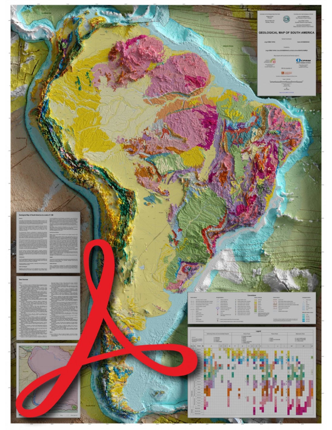
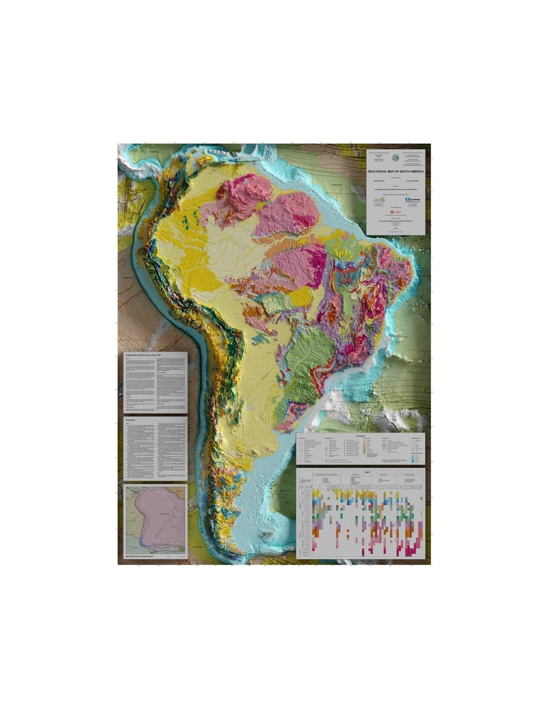
Scale: 1:5,000,000
Projection: polyconics Card size: 128 x 96 cm (1 sheet)
Co-publication CCGM - Servicio Geológico Colombiano - CPRM Serviço Geológico do Brazil (2022) - ASGMI Compiled by Jorge GÓMEZ TAPIAS, Carlos SCHOBBENHAUS and Nohora Emma MONTES RAMÍREZ. STRM: Shuttle Radar Topography Mission General Bathymetric Chart of the Oceans
DEM: Digital Elevation Model
Availability: In stock
Description
Carte géologique en relief de l’Amérique du Sud-PDF
Note: This map is subject to a licence agreement.
Le processus d’élaboration des modèles 3D est réalisé avec le logiciel Blender 3D. Il s’agit d’un outil de modélisation qui permet une représentation schématique à travers un ensemble d’objets et d’éléments, d’ombres et de textures ajoutés à une surface 3D initiale générée avec un DEM (GEBCO). Le travail, une fois rendu, deviendrait une image 3D, qui aura une résolution de 90 secondes d’arc (STRM90).
La Carte géologique en relief de l’Amérique du Sud-PDF en relief correspond à la nouvelle édition de la Carte géologique de l’Amérique du Sud de 2019 (GMSA), à échelle de 1/5 M, a été élaborée par la sous-commission de l’Amérique du Sud pour la Commission de la Carte Géologique du Monde (CCGM). Elle a été approuvée par l’Assemblée Générale de la CCGM tenue à Oslo (Norvège), lors du 33e Congrès International de Géologie.
Cette troisième version de la Carte géologique en relief de l’Amérique du Sud-PDF a été préparée avec la coopération de l’Association des Services Géologiques et Miniers Ibéro-américains (ASGMI), les Services Géologiques de l’Argentine, du Brésil, du Chili, de la Colombie, de l’Équateur, du Pérou et de l’Uruguay, ainsi que plusieurs universités et instituts de recherche supplémentaires, mentionnés dans les informations des collaborateurs.
The sub-commission adopted a methodology integrating the geological information of each country in the following way. Firstly, a new code was generated for each chronostratigraphic unit according to the proposed legend, using digital layers provided by the geological surveys of each country. Secondly, symbology and colours were created with patterns representative of the rock types and colours corresponding to the ages. Finally, a map with coded units was prepared at a scale of 1/5 M.
In order to generalise and link the units by hand, the GMSA was printed at a scale of 1/3 M with the new coding. The GMSA was then digitised and georeferenced to generalise the geological units, faults and folds at a scale of 1:5M. Once this was done, and despite the small scale of the map, the chronostratigraphic units, faults and folds on the map were adjusted using shaded relief imagery (NASA STRM) to improve the match between relief and mapped geological units. Finally, the geology between countries has been harmonised. It should be noted that the updating of the GMSA was carried out by consulting internationally indexed published articles.
The Geological Relief Map of South America-PDF is based on a polyconic projection (latitude × longitude), centred on the meridian -59°, datum WGS - 1984. Offshore data were extracted from the Tectonic Map of South America at a scale of 1/5.9M (Cordani et al., 2016); Seafloor Topography from the GEBCO 08 grid, version 20100927; and the crustal age grid: NCEI / NOAA.


